চিত্র:UNRWA Fields of Operations Map 2017.pdf

পূর্ণ রেজোলিউশন (১,৭৯৩ × ২,৫০২ পিক্সেল, ফাইলের আকার: ৭৩২ কিলোবাইট, এমআইএমই ধরন: application/pdf)
| এই ফাইলটি উইকিমিডিয়া কমন্স থেকে নেওয়া। সেখানের বর্ণনা পাতার বিস্তারিত নিম্নে দেখানো হলো। (সম্পাদনা)
|
সারাংশ
| বিবরণ |
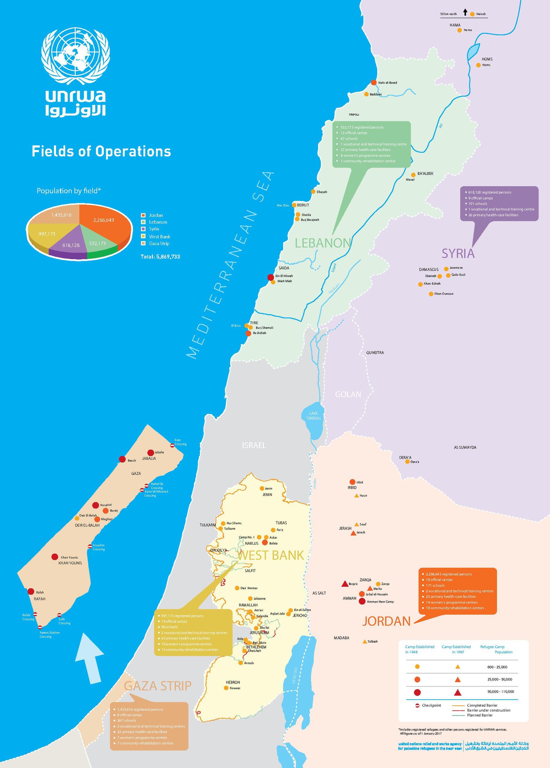
English: A map of the fields of operations of UNRWA, as of 1 January 2017 |
| তারিখ | |
| উৎস | United Nations Relief and Works Agency for Palestine Refugees in the Near East: Source |
| লেখক | United Nations Relief and Works Agency for Palestine Refugees in the Near East, United Nations |
| অন্যান্য সংস্করণ |
|
লাইসেন্স প্রদান
| This image is a map derived from a United Nations map.
Unless stated otherwise, UN maps are to be considered in the public domain. This applies worldwide. UN maps are, in principle, open source material and you can use them in your work or for making your own map. UN requests however that you delete the UN name, logo and reference number upon any modification to the map. Content of your map will be your responsibility. You can state in your publication, if you wish, something like: based on UN map … (map name, map number, revision number and date). See: Geospatial Information Section. And: Geospatial, location data for a better world. |
 |
ফাইলের ইতিহাস
যেকোনো তারিখ/সময়ে ক্লিক করে দেখুন ফাইলটি তখন কী অবস্থায় ছিল।
| তারিখ/সময় | সংক্ষেপচিত্র | মাত্রা | ব্যবহারকারী | মন্তব্য | |
|---|---|---|---|---|---|
| বর্তমান | ২০:৪৫, ১৬ ডিসেম্বর ২০১৮ |  | ১,৭৯৩ × ২,৫০২ (৭৩২ কিলোবাইট) | Jesuiseduardo | User created page with UploadWizard |
সংযোগসমূহ
নিচের পৃষ্ঠা(গুলো) থেকে এই ছবিতে সংযোগ আছে:
ফাইলের বৈশ্বিক ব্যবহার
নিচের অন্যান্য উইকিগুলো এই ফাইলটি ব্যবহার করে:
- en.wiki.x.io-এ ব্যবহার
- eo.wiki.x.io-এ ব্যবহার
- es.wiki.x.io-এ ব্যবহার
- fa.wiki.x.io-এ ব্যবহার
- fi.wiki.x.io-এ ব্যবহার
- fr.wiki.x.io-এ ব্যবহার
- id.wiki.x.io-এ ব্যবহার
- lt.wiki.x.io-এ ব্যবহার
- simple.wiki.x.io-এ ব্যবহার
- uz.wiki.x.io-এ ব্যবহার
- zh.wiki.x.io-এ ব্যবহার