চিত্র:Tarimrivermap.png

এই প্রাকদর্শনের আকার: ৮০০ × ৫৪৩ পিক্সেল। অন্যান্য আকারসমূহ: ৩২০ × ২১৭ পিক্সেল | ৬৪০ × ৪৩৪ পিক্সেল | ১,০২৪ × ৬৯৫ পিক্সেল | ১,৪৪৯ × ৯৮৩ পিক্সেল।
পূর্ণ রেজোলিউশন (১,৪৪৯ × ৯৮৩ পিক্সেল, ফাইলের আকার: ২.০৯ মেগাবাইট, এমআইএমই ধরন: image/png)
| এই ফাইলটি উইকিমিডিয়া কমন্স থেকে নেওয়া। সেখানের বর্ণনা পাতার বিস্তারিত নিম্নে দেখানো হলো। (সম্পাদনা)
|
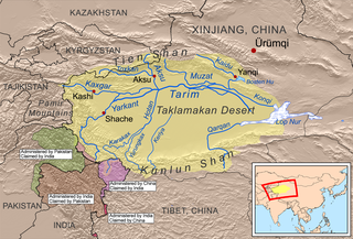
| বিবরণ | This is a map of the Tarim River drainage basin. Note that river courses shown crossing the Taklamakan Desert are usually dry. |
| তারিখ | |
| উৎস | Own work using Digital Chart of the World and GTOPO data, labels based on GEOnet. |
| লেখক | Kmusser |
আমি, এই কাজের স্বত্বাধিকারী, এতদ্দ্বারা আমি এই কাজকে নিম্ন বর্ণিত লাইসেন্সের আওতায় প্রকাশ করলাম:
এই ফাইলটি ক্রিয়েটিভ কমন্স অ্যাট্রিবিউশন-শেয়ার অ্যালাইক ৩.০ আনপোর্টেড লাইসেন্সের আওতায় লাইসেন্সকৃত।
- আপনি স্বাধীনভাবে:
- বণ্টন করতে পারেন – এ কাজটি অনুলিপি, বিতরণ এবং প্রেরণ করতে পারেন
- পুনঃমিশ্রণ করতে পারেন – কাজটি অভিযোজন করতে পারেন
- নিম্নের শর্তাবলীর ভিত্তিতে:
- স্বীকৃতিপ্রদান – আপনাকে অবশ্যই যথাযথ স্বীকৃতি প্রদান করতে হবে, লাইসেন্সের একটি লিঙ্ক সরবরাহ করতে হবে এবং কোনো পরিবর্তন হয়েছে কিনা তা নির্দেশ করতে হবে। আপনি যেকোনো যুক্তিসঙ্গত পদ্ধতিতে এটি করতে পারেন। কিন্তু এমন ভাবে নয়, যাতে প্রকাশ পায় যে লাইসেন্সধারী আপনাকে বা আপনার এই ব্যবহারের জন্য অনুমোদন দিয়েছে।
- একইভাবে বণ্টন – আপনি যদি কাজটি পুনঃমিশ্রণ, রুপান্তর, বা এর ওপর ভিত্তি করে নতুন সৃষ্টিকর্ম তৈরি করেন, তবে আপনাকে অবশ্যই আপনার অবদান একই লাইসেন্স বা একই রকমের লাইসেন্সের আওতায় বিতরণ করতে হবে।
ফাইলের ইতিহাস
যেকোনো তারিখ/সময়ে ক্লিক করে দেখুন ফাইলটি তখন কী অবস্থায় ছিল।
| তারিখ/সময় | সংক্ষেপচিত্র | মাত্রা | ব্যবহারকারী | মন্তব্য | |
|---|---|---|---|---|---|
| বর্তমান | ১৮:০৮, ১৩ এপ্রিল ২০২০ | | ১,৪৪৯ × ৯৮৩ (২.০৯ মেগাবাইট) | Kmusser | adjustments to China-India border claims |
| ১৩:১৭, ১১ মার্চ ২০২০ |  | ১,৪৪৯ × ৯৮৩ (২.০৯ মেগাবাইট) | Kmusser | crop out border | |
| ১৩:১৪, ১১ মার্চ ২০২০ |  | ১,৪৬৭ × ১,০০০ (২.১ মেগাবাইট) | Kmusser | update China-Tajikistan border | |
| ১৪:৩৬, ৩ ফেব্রুয়ারি ২০১০ |  | ১,৪৬৭ × ১,০০০ (২.১৮ মেগাবাইট) | Kmusser | fix typo | |
| ২০:৫৬, ১৫ ডিসেম্বর ২০০৮ |  | ১,৪৬৭ × ১,০০০ (২.১৮ মেগাবাইট) | Kmusser | {{Information |Description=This is a map of the Tarim River drainage basin. |Source=Own work using http://www.maproom.psu.edu/dcw/ Digital Chart of the World and [[http://edc.usgs.gov/products/elevation/gtopo30/ |
সংযোগসমূহ
নিচের পৃষ্ঠা(গুলো) থেকে এই ছবিতে সংযোগ আছে:
ফাইলের বৈশ্বিক ব্যবহার
নিচের অন্যান্য উইকিগুলো এই ফাইলটি ব্যবহার করে:
- af.wiki.x.io-এ ব্যবহার
- ar.wiki.x.io-এ ব্যবহার
- arz.wiki.x.io-এ ব্যবহার
- as.wiki.x.io-এ ব্যবহার
- azb.wiki.x.io-এ ব্যবহার
- az.wiki.x.io-এ ব্যবহার
- ba.wiki.x.io-এ ব্যবহার
- be.wiki.x.io-এ ব্যবহার
- bg.wiki.x.io-এ ব্যবহার
- br.wiki.x.io-এ ব্যবহার
- ca.wiki.x.io-এ ব্যবহার
- ceb.wiki.x.io-এ ব্যবহার
- cs.wiki.x.io-এ ব্যবহার
- da.wiki.x.io-এ ব্যবহার
- de.wiki.x.io-এ ব্যবহার
- en.wiki.x.io-এ ব্যবহার
এই ফাইলের অন্যান্য বৈশ্বিক ব্যবহার দেখুন।