চিত্র:Spseaice sss 2012170 chart.jpg
এর চেয়ে বেশি রেজোলিউশন লভ্য নয়।
Spseaice_sss_2012170_chart.jpg (৭২০ × ১৮৩ পিক্সেল, ফাইলের আকার: ১৭ কিলোবাইট, এমআইএমই ধরন: image/jpeg)
| এই ফাইলটি উইকিমিডিয়া কমন্স থেকে নেওয়া। সেখানের বর্ণনা পাতার বিস্তারিত নিম্নে দেখানো হলো। (সম্পাদনা)
|

|
This graph image could be re-created using vector graphics as an SVG file. This has several advantages; see Commons:Media for cleanup for more information. If an SVG form of this image is available, please upload it and afterwards replace this template with
{{vector version available|new image name}}.
It is recommended to name the SVG file “Spseaice sss 2012170 chart.svg”—then the template Vector version available (or Vva) does not need the new image name parameter. |


সারাংশ
| বিবরণ |
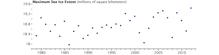
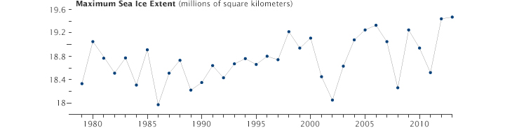
English: Antarctic sea ice cover reaches its minimum extent each year in February or March; the ice cover then grows until reaching its maximum extent in September or October. The graph above shows the maximum extent for each September since 1979 in millions of square kilometers. There is variability from year to year, though the overall trend shows growth of about 1.5 percent per decade. |
| তারিখ | |
| উৎস | http://eoimages.gsfc.nasa.gov/images/imagerecords/82000/82160/spseaicemax_extent_chart_2013.jpg |
| লেখক | NASA Earth Observatory |
Southern Ocean around Antarctica
লাইসেন্স প্রদান
| এই ফাইলটি পাবলিক ডোমেইনে আছে কারণ এটি শুধুমাত্র নাসা কর্তৃক নির্মিত হয়েছিল। নাসার কপিরাইট নীতি হচ্ছে যে "নাসা কর্তৃক উল্লেখ না থাকলে নাসার উপাদান কপিরাইট দ্বারা সুরক্ষিত নয়"। (Template:PD-USGov, নাসার কপিরাইট নীতির পাতা অথবা জেপিএল চিত্র ব্যবহারের নীতি দেখুন।) | ||
 |
সতর্কবার্তা:
|
ফাইলের ইতিহাস
যেকোনো তারিখ/সময়ে ক্লিক করে দেখুন ফাইলটি তখন কী অবস্থায় ছিল।
| তারিখ/সময় | সংক্ষেপচিত্র | মাত্রা | ব্যবহারকারী | মন্তব্য | |
|---|---|---|---|---|---|
| বর্তমান | ১৫:৪৯, ২৪ জুন ২০১৫ | ৭২০ × ১৮৩ (১৭ কিলোবাইট) | HLHJ | User created page with UploadWizard |
সংযোগসমূহ
নিচের পৃষ্ঠা(গুলো) থেকে এই ছবিতে সংযোগ আছে: