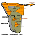
চিত্র:Plan Odendaal.png
Plan_Odendaal.png (৪১৮ × ৪১৮ পিক্সেল, ফাইলের আকার: ৩৩ কিলোবাইট, এমআইএমই ধরন: image/png)
ফাইলের ইতিহাস
যেকোনো তারিখ/সময়ে ক্লিক করে দেখুন ফাইলটি তখন কী অবস্থায় ছিল।
| তারিখ/সময় | সংক্ষেপচিত্র | মাত্রা | ব্যবহারকারী | মন্তব্য | |
|---|---|---|---|---|---|
| বর্তমান | ২২:০০, ২৫ নভেম্বর ২০২৩ |  | ৪১৮ × ৪১৮ (৩৩ কিলোবাইট) | LoomCreek | Transparency |
| ০৭:৪০, ২১ এপ্রিল ২০০৫ |  | ৪১৮ × ৪১৮ (১৫ কিলোবাইট) | Bries | This map shows the Odendaal Commission Plan for Namibia of 1964. The plan divided Namibia into ''Bantustans'' or ''Homelands''. I have created the map for the Wikipedia community. Category:Maps of Namibia {{GFDL}} |
সংযোগসমূহ
নিচের পৃষ্ঠা(গুলো) থেকে এই ছবিতে সংযোগ আছে:
ফাইলের বৈশ্বিক ব্যবহার
নিচের অন্যান্য উইকিগুলো এই ফাইলটি ব্যবহার করে:
- af.wiki.x.io-এ ব্যবহার
- ar.wiki.x.io-এ ব্যবহার
- ast.wiki.x.io-এ ব্যবহার
- ca.wiki.x.io-এ ব্যবহার
- Bantustan
- Hereros
- Resolució 301 del Consell de Seguretat de les Nacions Unides
- Resolució 309 del Consell de Seguretat de les Nacions Unides
- Resolució 310 del Consell de Seguretat de les Nacions Unides
- Resolució 319 del Consell de Seguretat de les Nacions Unides
- Resolució 323 del Consell de Seguretat de les Nacions Unides
- Resolució 342 del Consell de Seguretat de les Nacions Unides
- Resolució 366 del Consell de Seguretat de les Nacions Unides
- ckb.wiki.x.io-এ ব্যবহার
- de.wiki.x.io-এ ব্যবহার
- en.wiki.x.io-এ ব্যবহার
- South West Africa
- History of Namibia
- Bantustan
- Kaokoland
- Bushmanland (South West Africa)
- Hereroland
- Ovamboland
- Damaraland
- Tswanaland
- Kavangoland
- Rehoboth (homeland)
- Namaland
- East Caprivi
- Fox Odendaal
- Diocese of Namibia
- United Nations Security Council Resolution 301
- Land reform in Namibia
- Aminuis
- Constance Kgosiemang
- es.wiki.x.io-এ ব্যবহার
এই ফাইলের অন্যান্য বৈশ্বিক ব্যবহার দেখুন।


