চিত্র:Map provinces Netherlands-en.svg

এই SVG ফাইলের জন্য এই PNG প্রাকদর্শনের আকার: ৫০৬ × ৬০০ পিক্সেল। অন্যান্য আকারসমূহ: ২০২ × ২৪০ পিক্সেল | ৪০৫ × ৪৮০ পিক্সেল | ৬৪৮ × ৭৬৮ পিক্সেল | ৮৬৪ × ১,০২৪ পিক্সেল | ১,৭২৭ × ২,০৪৮ পিক্সেল | ৭৪৩ × ৮৮১ পিক্সেল।
পূর্ণ রেজোলিউশন (এসভিজি ফাইল, সাধারণত ৭৪৩ × ৮৮১ পিক্সেল, ফাইলের আকার: ১,০০৩ কিলোবাইট)
| এই ফাইলটি উইকিমিডিয়া কমন্স থেকে নেওয়া। সেখানের বর্ণনা পাতার বিস্তারিত নিম্নে দেখানো হলো। (সম্পাদনা)
|
এই W3C-অনির্দিষ্ট ভেক্টর চিত্রটি Inkscape দিয়ে তৈরি করা হয়েছে .

|
এই SVG ফাইলটি এমবেড করা লেখা ব্যবহার করে যা SVG অনুবাদ সরঞ্জাম বা যেকোন SVG সম্পাদক যেমন ইন্কস্কেপ বা অ্যাডবি ইলাস্ট্রেটর ব্যবহার করে আপনার ভাষায় অনুবাদ করা যাবে। আরো তথ্যের জন্য, SVG ফাইলগুলি অনুবাদ করা দেখুন। |
সারাংশ
| বিবরণ |
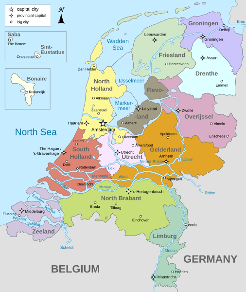
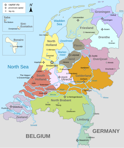
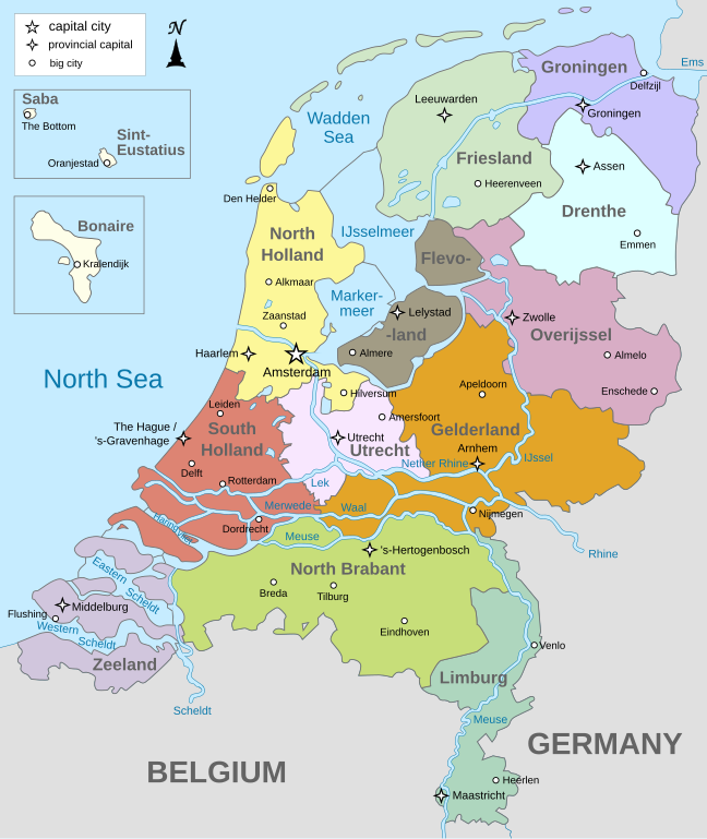
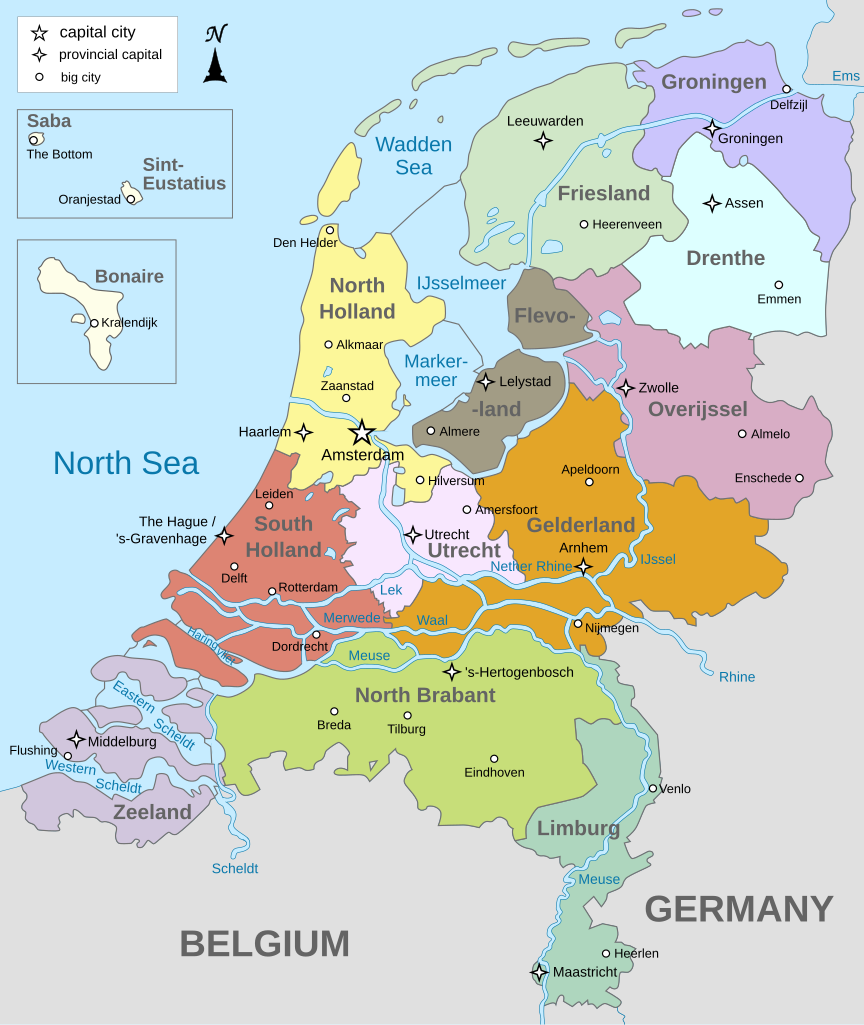
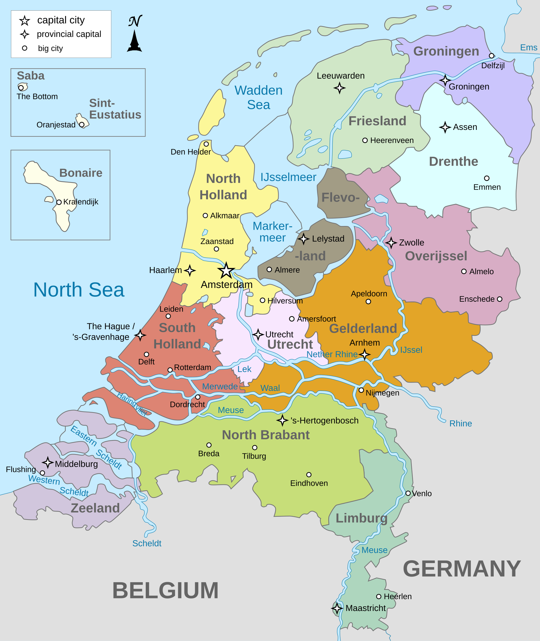
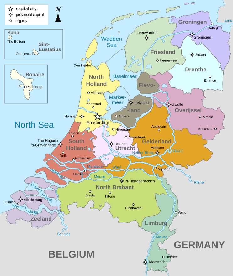
English: Map of The Netherlands (including the special municipalities of Saba, Saint Eustatius and Bonaire; the Caribbean Netherlands), showing provinces, large cities, rivers and lakes. English version
Deutsch: Karte der Niederlande, mit den Provinzen, der Karibischen Niederlande, den Großstädten und den Flüssen und Seen. Englische Version
Bahasa Indonesia: Peta Belanda (termasuk munisipal khusus Saba, Saint Eustatius dan Bonaire; Belanda Karibia), menampilkan provinsi, kota besar, sungai dan danau. Versi bahasa Inggris |
| তারিখ | |
| উৎস | নিজের কাজ |
| লেখক | Alphathon |
| অন্যান্য সংস্করণ |
[]
|


.svg)
লাইসেন্স প্রদান
আমি, এই কাজের স্বত্বাধিকারী, এতদ্দ্বারা আমি এই কাজকে নিম্ন বর্ণিত লাইসেন্সের আওতায় প্রকাশ করলাম:
এই ফাইলটি ক্রিয়েটিভ কমন্স অ্যাট্রিবিউশন-শেয়ার অ্যালাইক ৩.০ আনপোর্টেড লাইসেন্সের আওতায় লাইসেন্সকৃত।
- আপনি স্বাধীনভাবে:
- বণ্টন করতে পারেন – এ কাজটি অনুলিপি, বিতরণ এবং প্রেরণ করতে পারেন
- পুনঃমিশ্রণ করতে পারেন – কাজটি অভিযোজন করতে পারেন
- নিম্নের শর্তাবলীর ভিত্তিতে:
- স্বীকৃতিপ্রদান – আপনাকে অবশ্যই যথাযথ স্বীকৃতি প্রদান করতে হবে, লাইসেন্সের একটি লিঙ্ক সরবরাহ করতে হবে এবং কোনো পরিবর্তন হয়েছে কিনা তা নির্দেশ করতে হবে। আপনি যেকোনো যুক্তিসঙ্গত পদ্ধতিতে এটি করতে পারেন। কিন্তু এমন ভাবে নয়, যাতে প্রকাশ পায় যে লাইসেন্সধারী আপনাকে বা আপনার এই ব্যবহারের জন্য অনুমোদন দিয়েছে।
- একইভাবে বণ্টন – আপনি যদি কাজটি পুনঃমিশ্রণ, রুপান্তর, বা এর ওপর ভিত্তি করে নতুন সৃষ্টিকর্ম তৈরি করেন, তবে আপনাকে অবশ্যই আপনার অবদান একই লাইসেন্স বা একই রকমের লাইসেন্সের আওতায় বিতরণ করতে হবে।

|
এই নথি অনুলিপি, বিতরণ এবং/বা পরিবর্তন করার অনুমতি ফ্রি সফটওয়্যার ফাউন্ডেশন কর্তৃক প্রকাশিত গনু ফ্রি ডকুমেন্টেশন লাইসেন্স, সংস্করণ ১.২ বা তার পরবর্তী সংস্করণের আওতায় অনুমতিপ্রাপ্ত; যে কোনো রকম অনুচ্ছেদ পরিবর্তন, সম্মুখ-প্রচ্ছদের লেখা, পিছন-প্রচ্ছদের লেখা পরিবর্তন করা ছাড়াই। এই লাইসেন্সের একটি অনুলিপি গনু ফ্রি ডকুমেন্টেশন লাইসেন্স শিরোনামের অনুচ্ছেদে অন্তর্ভুক্ত করা আছে। |
আপনি আপনার পছন্দসই লাইসেন্স নির্বাচন করতে পারেন।
ফাইলের ইতিহাস
যেকোনো তারিখ/সময়ে ক্লিক করে দেখুন ফাইলটি তখন কী অবস্থায় ছিল।
| তারিখ/সময় | সংক্ষেপচিত্র | মাত্রা | ব্যবহারকারী | মন্তব্য | |
|---|---|---|---|---|---|
| বর্তমান | ১৯:২৮, ১৯ জানুয়ারি ২০২৪ | | ৭৪৩ × ৮৮১ (১,০০৩ কিলোবাইট) | Illchy | File uploaded using svgtranslate tool (https://svgtranslate.toolforge.org/). Added translation for id. |
| ১৭:৪৩, ২৯ এপ্রিল ২০২৩ |  | ৭৪৩ × ৮৮১ (৯৮৭ কিলোবাইট) | Dymitr | File uploaded using svgtranslate tool (https://svgtranslate.toolforge.org/). Added translation for be-tarask. | |
| ০৯:২৭, ২৫ নভেম্বর ২০২১ |  | ৭৪৩ × ৮৮১ (৯০৯ কিলোবাইট) | Andrei Stroe | File uploaded using svgtranslate tool (https://svgtranslate.toolforge.org/). Added translation for ro. | |
| ০৮:৩৯, ১২ এপ্রিল ২০১৯ |  | ৭৪৩ × ৮৮১ (৮১১ কিলোবাইট) | Thayts | Tweaked text position | |
| ১১:৩২, ১৭ ফেব্রুয়ারি ২০১৯ |  | ৭৪৩ × ৮৮১ (৮১১ কিলোবাইট) | Thayts | Fixed svg | |
| ১১:১৮, ১৭ ফেব্রুয়ারি ২০১৯ |  | ৭৪৩ × ৮৮১ (৮১১ কিলোবাইট) | Thayts | Added a bit more spacing between Eastern/Western and Scheldt | |
| ১১:০৬, ১৭ ফেব্রুয়ারি ২০১৯ |  | ৭৪৩ × ৮৮১ (৮১১ কিলোবাইট) | Thayts | Fixed Eastern Scheldt which wasn't rendered by the MediaWiki engine; removed Belgian city of Antwerp | |
| ০৫:২১, ১৪ ফেব্রুয়ারি ২০১৯ |  | ৭৪৩ × ৮৮১ (৮০৯ কিলোবাইট) | Alphathon | Updated borders | |
| ২০:৩৪, ২৩ আগস্ট ২০১৫ |  | ৭৪৩ × ৮৮১ (৮৪৭ কিলোবাইট) | Alphathon | Fixed stroke weight on a Friesland lake | |
| ২০:২৭, ২৩ আগস্ট ২০১৫ |  | ৭৪৩ × ৮৮১ (৮৪৭ কিলোবাইট) | Alphathon | Covered over the strokes at the mouths of rivers |
সংযোগসমূহ
নিচের পৃষ্ঠা(গুলো) থেকে এই ছবিতে সংযোগ আছে:
ফাইলের বৈশ্বিক ব্যবহার
নিচের অন্যান্য উইকিগুলো এই ফাইলটি ব্যবহার করে:
- ace.wiki.x.io-এ ব্যবহার
- af.wiki.x.io-এ ব্যবহার
- ang.wiki.x.io-এ ব্যবহার
- an.wiki.x.io-এ ব্যবহার
- ar.wiki.x.io-এ ব্যবহার
- ay.wiki.x.io-এ ব্যবহার
- azb.wiki.x.io-এ ব্যবহার
- be-tarask.wiki.x.io-এ ব্যবহার
- bg.wiki.x.io-এ ব্যবহার
- blk.wiki.x.io-এ ব্যবহার
- ceb.wiki.x.io-এ ব্যবহার
- diq.wiki.x.io-এ ব্যবহার
- en.wiki.x.io-এ ব্যবহার
- Netherlands
- Provinces of the Netherlands
- List of islands of the Netherlands
- King's commissioner
- Geology of the Netherlands
- File talk:Netherlands map large.png
- French war planning 1920–1940
- User talk:Gidonb/Archive 2008
- Template:Provinces of the Netherlands imagemap
- List of windmills in the Netherlands
- Provincial politics in the Netherlands
- 2008–09 KNVB Cup
- User:Alphathon/Gallery
- File talk:Netherlands Map.svg
- Portal:Islands
- Wikipedia:Reference desk/Archives/Humanities/2014 September 25
- en.wikiversity.org-এ ব্যবহার
- eu.wiki.x.io-এ ব্যবহার
- fa.wiki.x.io-এ ব্যবহার
- ff.wiki.x.io-এ ব্যবহার
- fi.wiki.x.io-এ ব্যবহার
- fr.wiki.x.io-এ ব্যবহার
- gl.wiki.x.io-এ ব্যবহার
- haw.wiki.x.io-এ ব্যবহার
- he.wiki.x.io-এ ব্যবহার
- ia.wiki.x.io-এ ব্যবহার
- id.wiki.x.io-এ ব্যবহার
এই ফাইলের অন্যান্য বৈশ্বিক ব্যবহার দেখুন।