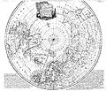
পূর্ণ রেজোলিউশন (১০,৯২৮ × ৯,৩৯২ পিক্সেল, ফাইলের আকার: ১৬.০৯ মেগাবাইট, এমআইএমই ধরন: image/jpeg)

এই ফাইলটি উইকিমিডিয়া কমন্স থেকে নেওয়া। সেখানের বর্ণনা পাতার বিস্তারিত নিম্নে দেখানো হলো। (সম্পাদনা)
উইকিমিডিয়া কমন্স, মুক্ত লাইসেন্সযুক্ত মিডিয়ার একটি ভান্ডার। আপনি সাহায্য করতে পারেন
সতর্কীকরণ মূল ফাইলে বড় সংখ্যার পিক্সেল আছে এবং এটি সঠিকভাবে লোড নাও হতে পারে বা আপনার ব্রাউজার নিশ্চল করে দিতে পারে। আন্তঃক্রিয়াশীল বড়-চিত্র-দর্শনকারী

সারাংশ

বর্ণনা
A map of the Arctic ocean and the surrounding continents, titled "A correct draught of the North Pole and of all the countries hitherto discovered, intercepted between the Pole and the parallel of 50 degrees"
তারিখ 1780-এর দশক
date QS:P,+1780-00-00T00:00:00Z/8
উৎস Memorial University Digital Archives Institute
স্রষ্টা
Emanuel Bowen  (১৬৯৪–১৭৬৭)  wikidata:Q330967
 
Emanuel Bowen
বিকল্প নাম
বিবরণ ব্রিটিশ cartographer এবং ছাপচিত্রী
জন্ম/মৃত্যু তারিখ ১৬৯৪ উইকিউপাত্তে এটি সম্পাদনা করুন ১৭৬৭ উইকিউপাত্তে এটি সম্পাদনা করুন
জন্ম/মৃত্যু স্থান ইংল্যান্ড রাজ্য উইকিউপাত্তে এটি সম্পাদনা করুন লন্ডন উইকিউপাত্তে এটি সম্পাদনা করুন
কর্মস্থল
কর্তৃপক্ষ নিয়ন্ত্রণ
creator QS:P170,Q330967
 Geotemporal data
ভৌগলিক সীমা
N: 79.216°N
W: 217.332°W E: 307.133°E
S: 2.819°S
Warper-এ মানচিত্রের আস্তরণ Wikimaps Warper-এ ভূউল্লেখকৃত মানচিত্র দেখুন
অন্যান্য সংস্করণ
Original image

লাইসেন্স প্রদান

This is a faithful photographic reproduction of a two-dimensional, public domain work of art. The work of art itself is in the public domain for the following reason:
Public domain

এই কর্মটি এর উৎস দেশে পাবলিক ডোমেইনে রয়েছে এবং অন্যান্য দেশ ও অঞ্চলে যেখানে কপিরাটের সময়সীমা হচ্ছে লেখকের জীবন যোগ ১০০ বছর বা তাঁর কম


You must also include a United States public domain tag to indicate why this work is in the public domain in the United States.
এই ফাইলটি কপিরাইট আইনের আওতায় জানা সকল বাধানিষেধ মুক্ত বলে চিহ্নিত হয়েছে, যার মধ্যে সম্পর্কিত সকল স্বত্ব ও নেইবারিং সত্ত্ব সংযুক্ত।
The official position taken by the Wikimedia Foundation is that "faithful reproductions of two-dimensional public domain works of art are public domain".
This photographic reproduction is therefore also considered to be in the public domain in the United States. In other jurisdictions, re-use of this content may be restricted; see Reuse of PD-Art photographs for details.

ক্যাপশন

এই ফাইলটি কী উপস্থাপন করছে তার এক লাইন ব্যাখ্যা যোগ করুন

এই ফাইলে চিত্রিত আইটেমগুলি

যা চিত্রিত করে

ফাইলের ইতিহাস

যেকোনো তারিখ/সময়ে ক্লিক করে দেখুন ফাইলটি তখন কী অবস্থায় ছিল।

তারিখ/সময়সংক্ষেপচিত্রমাত্রাব্যবহারকারীমন্তব্য
বর্তমান১৮:৫০, ২২ নভেম্বর ২০১১১৮:৫০, ২২ নভেম্বর ২০১১-এর সংস্করণের সংক্ষেপচিত্র১০,৯২৮ × ৯,৩৯২ (১৬.০৯ মেগাবাইট)Xijky{{Information |Description=A map of the Arctic ocean and the surrounding continents, titled "A correct draught of the North Pole and of all the countries hitherto discovered, intercepted between the Pole and the parallel of 50 degrees" |Source=[http://col

নিচের পৃষ্ঠা(গুলো) থেকে এই ছবিতে সংযোগ আছে:

ফাইলের বৈশ্বিক ব্যবহার

নিচের অন্যান্য উইকিগুলো এই ফাইলটি ব্যবহার করে: