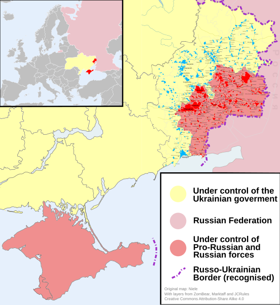
চিত্র:2014 Russo-ukrainian-conflict map.svg

এই SVG ফাইলের জন্য এই PNG প্রাকদর্শনের আকার: ৫৫২ × ৫৯৯ পিক্সেল। অন্যান্য আকারসমূহ: ২২১ × ২৪০ পিক্সেল | ৪৪২ × ৪৮০ পিক্সেল | ৭০৭ × ৭৬৮ পিক্সেল | ৯৪৩ × ১,০২৪ পিক্সেল | ১,৮৮৬ × ২,০৪৮ পিক্সেল | ৪,১২৬ × ৪,৪৮০ পিক্সেল।
পূর্ণ রেজোলিউশন (এসভিজি ফাইল, সাধারণত ৪,১২৬ × ৪,৪৮০ পিক্সেল, ফাইলের আকার: ২.৭৫ মেগাবাইট)
ফাইলের ইতিহাস
যেকোনো তারিখ/সময়ে ক্লিক করে দেখুন ফাইলটি তখন কী অবস্থায় ছিল।
| তারিখ/সময় | সংক্ষেপচিত্র | মাত্রা | ব্যবহারকারী | মন্তব্য | |
|---|---|---|---|---|---|
| বর্তমান | ১৬:০৩, ৯ অক্টোবর ২০১৪ |  | ৪,১২৬ × ৪,৪৮০ (২.৭৫ মেগাবাইট) | Mondolkiri1 | Marinka and Novotroitske - http://militarymaps.info/ |
| ০৩:২৭, ৯ অক্টোবর ২০১৪ |  | ৪,১২৬ × ৪,৪৮০ (২.৭৫ মেগাবাইট) | Mondolkiri1 | Update according to http://militarymaps.info/ and other sources provided in File:East Ukraine Conflict.svg | |
| ২৩:৩০, ৬ অক্টোবর ২০১৪ |  | ৪,১২৬ × ৪,৪৮০ (২.৭৪ মেগাবাইট) | Mondolkiri1 | Corrected Zolote and added Novoslapa | |
| ২৩:২০, ৬ অক্টোবর ২০১৪ |  | ৪,১২৬ × ৪,৪৮০ (২.৭৪ মেগাবাইট) | Mondolkiri1 | Update according to http://militarymaps.info/ , http://www.segodnya.ua/regions/donetsk/moskal-boeviki-obyavili-na-menya-ohotu-558223.html and other sources in my talk page | |
| ০৭:১৩, ৫ অক্টোবর ২০১৪ |  | ৪,১২৬ × ৪,৪৮০ (২.৭৪ মেগাবাইট) | Mondolkiri1 | Update Donbass according to File:East Ukraine Conflict.svg | |
| ১৭:৫০, ১৯ সেপ্টেম্বর ২০১৪ |  | ৪,১২৬ × ৪,৪৮০ (২.৭৩ মেগাবাইট) | Hanibal911 | POV Vandalism I revert all unjustified changes which was made based unreliable sources | |
| ০৭:৪৬, ১৯ সেপ্টেম্বর ২০১৪ |  | ৪,১২৬ × ৪,৪৮০ (২.৭১ মেগাবাইট) | Niele~commonswiki | - Added Lutuhyne tot the red area as suggested by user Mondolkiri1 - Updated legenda and unclear/conflicting report-colours. This was a constructive way to prevent discussions, edit warring on basis of conflicting sources | |
| ১৩:২৬, ১৮ সেপ্টেম্বর ২০১৪ |  | ৪,১২৬ × ৪,৪৮০ (২.৭৩ মেগাবাইট) | Hanibal911 | POV Pushing we not use this not correct maps which contradicts to many sources | |
| ১৩:০১, ১৮ সেপ্টেম্বর ২০১৪ |  | ৪,১২৬ × ৪,৪৮০ (২.৭ মেগাবাইট) | Niele~commonswiki | Not true, http://mediarnbo.org/ is the official communication-website of Ukrainean Forces, while http://liveuamap.com is unofficial map hosted from the us.Reverted to version as of 12:40, 18 September 2014 | |
| ১২:৪৪, ১৮ সেপ্টেম্বর ২০১৪ |  | ৪,১২৬ × ৪,৪৮০ (২.৭৩ মেগাবাইট) | Mondolkiri1 | Reverted to version as of 12:32, 18 September 2014 Sorry, but the http://liveuamap.com/ is the official Ukrainian ATO site, and as I said, Lutuhyne is in the pink area there, not in the foggy zone! |
সংযোগসমূহ
নিচের পৃষ্ঠা(গুলো) থেকে এই ছবিতে সংযোগ আছে:
ফাইলের বৈশ্বিক ব্যবহার
নিচের অন্যান্য উইকিগুলো এই ফাইলটি ব্যবহার করে:
- af.wiki.x.io-এ ব্যবহার
- cs.wiki.x.io-এ ব্যবহার
- de.wiki.x.io-এ ব্যবহার
- en.wiki.x.io-এ ব্যবহার
- fi.wiki.x.io-এ ব্যবহার
- he.wiki.x.io-এ ব্যবহার
- incubator.wikimedia.org-এ ব্যবহার
- it.wikiquote.org-এ ব্যবহার
- ja.wiki.x.io-এ ব্যবহার
- ka.wiki.x.io-এ ব্যবহার
- lv.wiki.x.io-এ ব্যবহার
- mk.wiki.x.io-এ ব্যবহার
- ne.wiki.x.io-এ ব্যবহার
- nl.wiki.x.io-এ ব্যবহার
- pt.wiki.x.io-এ ব্যবহার
- ru.wikinews.org-এ ব্যবহার
- ru.wikiquote.org-এ ব্যবহার
- sd.wiki.x.io-এ ব্যবহার
- te.wiki.x.io-এ ব্যবহার
- uk.wiki.x.io-এ ব্যবহার
- uk.wikiquote.org-এ ব্যবহার
- vi.wiki.x.io-এ ব্যবহার


